
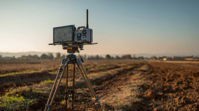
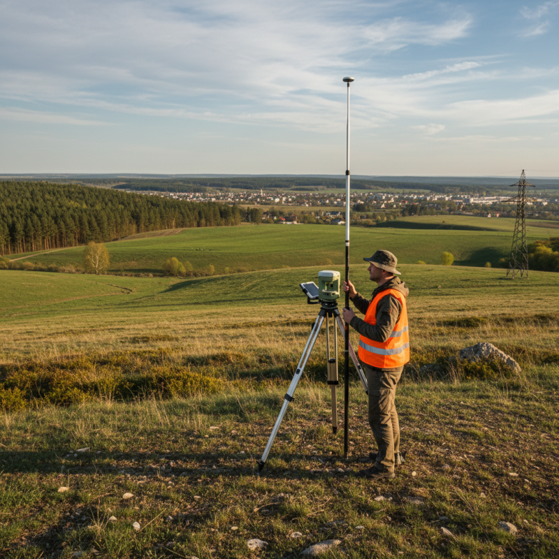
In the world of land surveying, things are always changing, but one thing’s for sure—it’s all about accuracy. Using an RTK GPS Land Survey Machine can really make a difference when it comes to mapping out land things more precisely. These devices use real-time kinematic tech, which means surveyors can gather data with way fewer errors. Companies like Trimble and Leica Geosystems have come up with some pretty innovative solutions to meet the rising demand for super accurate land surveys.
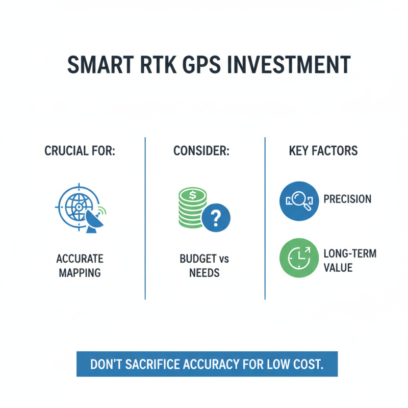
Picking the right Rtk Gps device isn’t just about one-size-fits-all. You’ve gotta think about your specific project — some jobs need quick data collection, while others call for detailed, pinpoint accuracy. Different models come with their own set of features, so taking a little time to review your options can save you a lot of headaches later on.
Of course, even with all these fancy tools, it’s not always smooth sailing. Not every environment is perfect for RTK GPS — things like dense trees, tall buildings, or bad weather can throw a wrench in the works. That’s why surveyors need to stay flexible and keep refining their techniques. The key is having the right tools and a skilled team — together, they set you up for a successful survey every time.
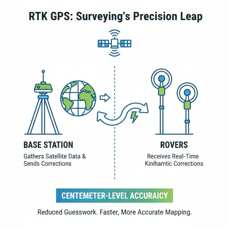
RTK GPS technology has transformed land surveying. It offers centimeter-level accuracy, which is essential for precise mapping. Using RTK systems reduces the guesswork in measurements. This technology employs a base station along with rovers. The base station collects data and sends corrections to the rovers. This real-time feedback ensures accuracy.
When using RTK GPS, pay attention to satellite visibility. Clouds or tall buildings can interfere with the signals. Position your base station in an open area for better reception.
Incorporating this technology can be challenging. Operators must be trained to handle equipment properly. Not every surveyor may feel comfortable with high-tech tools. Regular equipment maintenance is critical. Plan to conduct routine checks to avoid errors in data collection.
For efficiency, calibrate your equipment before each use. Understanding your terrain can help predict signal interruptions. Always keep backup methods ready when dealing with unpredictable environments.
When selecting RTK GPS survey machines, several key features stand out. Accuracy is paramount. According to industry reports, RTK GPS systems can achieve centimeter-level precision. This is crucial for land surveying and mapping tasks. Users should also consider the device's data transmission capabilities. Real-time corrections enhance the system’s reliability.
Battery life is another essential factor. Long-lasting batteries minimize downtime in the field. Some devices boast over 12 hours of continuous operation. This is vital for extensive survey areas. Additionally, user interface matters. Simple navigation can save time. Look for machines with intuitive screens and customizable settings.
Durability shouldn’t be overlooked. Many RTK GPS units face harsh environmental conditions. Waterproof and shock-resistant designs enhance longevity. A study indicated that around 25% of field equipment failure is due to environmental factors. Reflecting on this, it’s clear that investing in robust features is wise. Users must balance quality and affordability in their decisions.
When selecting an Rtk Gps Land Survey Machine, accuracy plays a vital role. Each machine offers unique features for mapping. It is essential to know which design suits your projects. Some may excel in data collection speed, while others prioritize precision. Evaluating the user interface can help you operate the device smoothly. A steep learning curve might discourage new users.
Durability is key for land surveys. Machines exposed to harsh climates should provide reliable performance. Consider the weight of the device as well. Heavier machines might be difficult to handle in uneven terrain. Battery life is another critical factor to reflect upon. A short battery might hinder long working hours in the field.
Additionally, think about the support and training offered. Some machines come with extensive manuals, while others may have online resources. This could make a difference when troubleshooting. Ultimately, reflecting on these factors will help ensure you choose the best Rtk Survey Machine for your needs.
| Model | Accuracy (cm) | Range (m) | Weight (kg) | Battery Life (hours) | Operating Temperature (°C) |
|---|---|---|---|---|---|
| Model A | 1.0 | 1000 | 1.5 | 12 | -20 to 60 |
| Model B | 1.5 | 800 | 1.8 | 10 | -10 to 50 |
| Model C | 2.0 | 600 | 2.0 | 15 | -30 to 55 |
| Model D | 1.2 | 1200 | 1.2 | 11 | -15 to 60 |
| Model E | 1.8 | 900 | 1.6 | 14 | -20 to 50 |
| Model F | 1.3 | 700 | 2.3 | 9 | -10 to 45 |
| Model G | 0.8 | 1500 | 1.1 | 13 | -20 to 65 |
| Model H | 1.4 | 1100 | 1.0 | 16 | -15 to 62 |
| Model I | 1.6 | 750 | 1.4 | 10 | -20 to 50 |
| Model J | 1.7 | 1300 | 1.3 | 12 | -15 to 58 |
Accuracy is crucial in land surveying. RTK GPS systems provide high precision for mapping tasks. These machines use signals from satellites to determine locations within centimeters. Users need to understand that even slight interference can affect accuracy. Factors such as weather, buildings, or trees may cause issues. This is an important consideration for surveyors in the field.
When evaluating GPS performance, it’s vital to test different terrains. Some areas may yield better results than others. For example, urban locations can complicate signal reception. Equipment calibration is also key, impacting overall performance. Users should regularly check settings for optimal efficiency. Despite advancements, RTK GPS systems are not infallible. They require careful operation and sometimes, a bit of patience.
Innovations in RTK GPS technology have transformed modern surveying practices. This technology provides centimeter-level accuracy, crucial for land surveys. According to a recent industry report, the global RTK GPS market is expected to grow by 10% annually. This rise indicates a strong demand for precise mapping solutions.
Rtk Machines employ real-time data correction. They transmit signals from a base station to the roving receiver in real-time. As a result, users can achieve high precision quickly. However, challenges remain in urban environments. Signal interference can reduce accuracy, highlighting the need for improved systems. In some cases, users struggle with satellite availability, which can affect performance significantly.
Another aspect is user training. Many operators lack comprehensive knowledge of RTK systems. Proper training can enhance the effectiveness of these machines. Without it, the technology's full potential may not be realized. As the surveying landscape changes, continued innovation will be key. Advanced Rtk Machines must not only be accurate but also user-friendly and adaptable to diverse environments.
Investing in RTK GPS equipment is crucial for accurate mapping. However, it’s essential to consider your budget. High-quality RTK GPS devices can be expensive. Evaluate your needs before making decisions. Cheaper models may seem appealing, but they often lack precision. Think about long-term costs versus initial investment.
Tips: Always factor in maintenance costs. Some machines require more upkeep. This can add to your overall expenses.
Another point to consider is software compatibility. Some products might have hidden fees for updates. Do thorough research before purchasing. This can prevent future frustrations.
Accurate mapping requires reliable tools like a Topography Machine. However, spending too much or too little can lead to setbacks. Take your time to weigh the options. A balanced budget is vital for successful projects.
When considering Land Survey Gps Equipment, user reviews offer invaluable insight. Many users appreciate precision, but some report issues. For example, calibration can be tricky. One surveyor mentioned that he often double-checks measurements. While the device promises accuracy, it's essential to understand its limitations. Such experiences guide fellow users in making informed choices.
Expert recommendations also play a vital role. Professionals often highlight battery life and ease of use. A robust unit can last over ten hours, which is crucial for long days in the field. However, not all devices meet this standard. Some users find themselves scrambling for chargers mid-survey, which can disrupt workflow. Furthermore, the size and weight matter too. Compact models are often favored, yet sacrifices in durability are common.
Overall, while the market offers a range of options, real-world experiences reveal a mix of strengths and weaknesses. The right choice hinges on your specific needs. Balancing features and user feedback could enhance the efficiency of your land surveys.
The integration of GNSS RTK positioning technology has revolutionized field operations, particularly in sectors like surveying, construction, and land management. A crucial advancement in this arena is the use of rugged tablets equipped with a cutting-edge Gnss Module capable of 1408 channels. This technology enables centimeter-level measurement accuracy, significantly enhancing the precision of field data collection. By ensuring the highest level of accuracy, professionals can make informed decisions quickly, minimizing errors and improving overall efficiency.
One standout feature of such a tablet is its user-friendly design, which allows professionals to seamlessly incorporate advanced technology into their daily tasks. The device not only provides reliable positioning data but also boasts robust construction, making it suitable for demanding environments. Its intuitive interface and capability for real-time data processing empower users to manage complex tasks with ease. This transformative tool paves the way for increased productivity and precision in field operations, making it an invaluable asset for any professional reliant on accurate data for planning and execution in challenging conditions.
: The main goal is to improve daily life efficiency. It helps with time management and organization.
Everyone can benefit, especially those juggling multiple tasks. It is useful for students, professionals, and busy parents.
It simplifies task tracking. You can prioritize better and plan your day effectively, leading to increased focus.
Yes, some users may feel overwhelmed initially. Adapting takes time, and not every method suits everyone.
Yes, it works for short and long-term goals. However, regular adjustments may be necessary as priorities change.
Support is available through various channels. Community forums and online guides can provide additional insights and help.
Yes, you can tailor it to fit personal workflows. Some trial and error may be needed to find the best setup.
Many similar products offer integration options. However, compatibility may vary, requiring some exploration to find the right fit.
Forgetting is common. Building a habit takes time, so set reminders or start with small, manageable goals.
The article "Top 10 RTK GPS Land Survey Machines for Accurate Mapping" provides a comprehensive overview of RTK GPS technology and its significance in land surveying. It outlines the essential features that surveyors should consider when selecting an RTK GPS land survey machine, emphasizing the importance of accuracy, precision, and innovative capabilities that enhance mapping efficiency. A comparative analysis of the top ten machines highlights their performance, usability, and any unique advancements that set them apart in modern surveying applications.
Additionally, the article discusses the financial aspects of budgeting for RTK GPS equipment, ensuring that survey professionals can make informed decisions without overspending. User reviews and expert recommendations for each device reinforce their potential effectiveness in the field, guiding readers toward selecting the most suitable RTK GPS land survey machine for their specific needs and projects. Overall, this resource serves as a valuable guide for anyone looking to enhance their surveying accuracy through advanced technology.
