inquiry
Leave Your Message
0%

Lately, the surveying and mapping world has been going through some pretty exciting changes, especially with how much more accurate and efficient things have become. A lot of this progress is thanks to Software Gnss Rtk(Real-Time Kinematic) tech really taking off. If you’ve seen the latest market reports, you'll notice that the Global Gnss market is projected to hit around$27 billion by 2026, and a big chunk of that growth is driven by improvements in RTK systems. These software solutions for GNSS RTK allow surveyors to get down to centimeter-level precision — which means less time and fewer labor expenses.

Unlocking Precision: How Software GNSS RTK Revolutionizes Surveying and Mapping

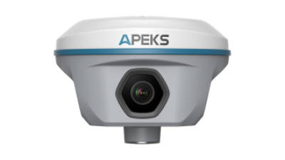
Based in Shanghai, Apekstool (or APEKS) is a trustworthy player in this space. They focus on innovative geospatial surveying tools and customized solutions, really recognizing just how much this tech can shake up traditional methods. With their expertise in GNSS/GPS systems, they’re right there at the forefront of this revolution, helping professionals achieve jaw-dropping accuracy and boosting productivity across the board.

Understanding GNSS RTK Technology: A Comprehensive Overview

GNSS RTK, which stands for Global Navigation Satellite System Real-Time Kinematic, is really a game-changer when it comes to surveying and mapping. Basically, it uses satellite signals along with real-time corrections to get you to centimeter-level accuracy—that's pretty impressive! This kind of precision is super important for things like land surveying, building projects, or even farming, where small errors can add up and cause big issues or extra costs. Because of GNSS RTK, traditional surveying methods have totally changed. Professionals can now gather and analyze spatial data much faster and more accurately than ever before.

So, how does it actually work? Well, it’s mainly made up of two parts: a base station and a rover. The base station stays put at a known, fixed location and keeps track of satellite signals, constantly calculating any errors in the data. It then sends this error info to the rover, which moves around to take measurements at different spots within the survey area. The rover uses the corrections from the base station to give really precise position readings. Since it’s easy to operate and allows for quick data collection, GNSS RTK has become an essential tool for surveyors and mappers out there. It’s definitely made workflows smoother and improved the quality of the data we rely on.

Honestly, once you start using it, it’s hard to go back to the old ways!

Surveying Efficiency Improvements with GNSS RTK Technology

This chart illustrates the percentage improvement in surveying efficiency when using GNSS RTK technology over traditional surveying methods across various surveying categories: land surveying, construction surveying, and geodetic surveying.

The Evolution of Surveying: From Traditional Methods to GNSS RTK

Surveying has come a long way, and it’s pretty exciting to see how much things have evolved. Back in the day, surveyors had to rely on manual measurements using clunky tools — which, let’s be honest, could be really slow and were often tricky because of human error. But things got a serious upgrade with the arrival of GNSS RTK technology. Now, things are faster, more accurate, and way more accessible. This tech uses satellite signals to give real-time, pinpoint positioning, so surveyors can get their work done quickly and with much more confidence.

At Shanghai Apekstool (or APEKS for short), we’re all about helping modern surveyors stay ahead with innovative geospatial solutions. Whether you’re using GNSS/GPS systems, total stations, or a range of surveying accessories, we've got you covered. Our goal is to empower professionals to make the most of the latest tech out there.

A little tip: When you're switching over to GNSS RTK, double-check that your gear is compatible and make sure your team gets proper training. Also, don’t forget to keep your software updated regularly — it’s key to unlocking new features and keeping your equipment running smoothly out in the field.

Key Advantages of Software GNSS RTK in Modern Surveying Practices

You know, GNSS Rtk Software has really shaken up how we approach modern surveying. It’s amazing how it can deliver centimeter-level accuracy in real-time—that’s a game-changer, especially because it cuts down so much on the time you'd normally spend on post-processing all that data. This kind of precision is super important when you’re dealing with projects where every detail counts, like building infrastructure or keeping tabs on the environment. Thanks to GNSS RTK, surveyors can make smarter decisions on the spot, which means better results and lower costs overall.

At Shanghai Apekstool (APEKS), we truly understand how crucial these cutting-edge GNSS and GPS systems are in today’s geospatial work. That’s why we’re all about creating solutions that don’t just improve accuracy but also make your workflow smoother—thanks to our easy-to-use software. We also offer personalized solutions and top-notch surveying gear to give professionals in the field the tools they need to really make the most out of this technology. As a trusted name in the industry, we're dedicated to pushing the boundaries of surveying with our state-of-the-art products—helping you get the job done right, every time.

Unlocking Precision: How Software GNSS RTK Revolutionizes Surveying and Mapping

Comparing GNSS RTK to Other Positioning Techniques in Mapping

GNSS RTK, which stands for Global Navigation Satellite System Real-Time Kinematic, has really shaken up the world of surveying and mapping. It’s a game-changer, offering way better accuracy and speed compared to the old-school methods we used to rely on. If you’ve worked with differential GPS or traditional land surveys, you know those can be slow and sometimes not as precise. But with GNSS RTK, it uses satellite signals and ground-based reference stations to get you centimeter-level precision — and it happens in real time! This tech lets surveyors gather geospatial data way faster, really boosting efficiency and cutting down project turnaround times quite a bit.

At Shanghai Apekstool (or APEKS), we totally get how important GNSS RTK is looking forward in the world of geospatial surveying. We’ve got some pretty advanced GNSS systems designed to perform well in all kinds of situations — whether it’s civil engineering, land management, or other applications. By mixing RTK tech with our lineup of total stations, levels, and surveying software, we’re able to offer solutions tailored to what our clients really need. And as we keep pushing forward, we’re all about improving our tools to bring even more accuracy and dependability to the industry, making surveying smoother and more reliable than ever.

Unlocking Precision: How Software GNSS RTK Revolutionizes Surveying and Mapping

Real-World Applications of GNSS RTK in Surveying and Mapping Industries

You know, GNSS RTK technology has really shaken up the surveying and mapping worlds. It’s like having superpowered precision—surveyors can now get centimeter-level accuracy on the spot, which means things move faster, and there’s less need to double-check everything out in the field. It’s pretty cool how this tech is being used across different areas like construction, farming, and environmental monitoring. It makes data flow smoothly, and decisions get a lot easier to make.

If you want to get the most out of GNSS RTK, a few tips can help. Regularly checking and maintaining your equipment is a must—that way, you keep everything accurate. Also, using correction signals from multiple satellites can really boost reliability. And don’t forget training your team on how to interpret the data properly; it makes a huge difference. Setting up your GNSS station carefully, especially considering things like trees or buildings nearby, can seriously cut down on errors.

In farming, GNSS RTK helps farmers with precision crop management—meaning they can plan planting better and reduce waste. Over in construction, it speeds up site surveys and helps position machinery precisely, so projects stay on track and on budget. All in all, diving into GNSS RTK really can lead to major improvements in how accurately and quickly things get done across different industries.

Enhancing Precision in Surveying: The Role of AP60 Vision GNSS Receiver in Modern Geospatial Applications

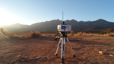
In the rapidly evolving world of geospatial applications, precision is paramount. The introduction of advanced GNSS (Global Navigation Satellite System) receivers, such as the AP60 Vision GNSS Receiver, marks a significant step forward in enhancing surveying accuracy. According to a report by the International Association of Geodesy, the demand for high-precision geospatial data has surged by 20% annually over the past five years, driven primarily by developments in civil engineering, construction, and environmental monitoring.

The AP60 Vision GNSS Receiver stands at the forefront of this trend, offering unparalleled accuracy and reliability. Equipped with cutting-edge technology, it provides real-time positioning with centimeter-level precision. A study from Geospatial World indicated that the integration of high-precision GNSS technology into surveying practices can reduce data collection errors by up to 50%, significantly improving project outcomes and reducing costs. This makes the AP60 an invaluable tool for surveyors and geospatial professionals who demand reliability in challenging environments.

Moreover, as smart city initiatives and autonomous vehicle projects proliferate, the need for precise geospatial data is more critical than ever. The AP60 Vision GNSS Receiver's ability to integrate with various mapping and modeling applications positions it as an essential resource in the toolkit of modern surveyors. In a market projected to reach $80 billion by 2025, the advancements in GNSS technology not only enhance precision but also broaden the scope of geospatial applications, enabling professionals to meet the growing demands of the industry efficiently.

FAQS

: What is GNSS RTK technology?

: GNSS RTK stands for Global Navigation Satellite System Real-Time Kinematic technology, which uses satellite signals and real-time data corrections to achieve centimeter-level accuracy in positioning.

How does GNSS RTK improve surveying and mapping?

GNSS RTK enhances surveying and mapping by providing highly accurate positioning data, reducing discrepancies, increasing efficiency, and minimizing costs associated with errors.

What are the main components of a GNSS RTK system?

The main components of a GNSS RTK system are a base station, which is fixed at a known location and receives satellite signals, and a rover, which is mobile and measures positions within the survey area using corrected data from the base station.

Why is centimeter-level accuracy important in surveying?

Centimeter-level accuracy is crucial in surveying because even small errors can lead to significant issues such as construction mistakes and increased project costs.

How has surveying evolved with the introduction of GNSS RTK technology?

Surveying has evolved from manual methods and cumbersome tools to more efficient and accurate processes using GNSS RTK technology, allowing for real-time precise positioning and faster task completion.

What should professionals consider when transitioning to GNSS RTK?

Professionals should ensure their equipment is compatible, provide thorough training for their team, and regularly update software to maximize the benefits of GNSS RTK technology.

What types of products does Shanghai Apekstool offer for modern surveyors?

Shanghai Apekstool offers a range of innovative geospatial surveying and mapping products, including GNSS/GPS systems, total stations, and various surveying accessories.

What impact has GNSS RTK technology had on workflow efficiency?

The integration of GNSS RTK technology has significantly enhanced workflow efficiency for surveyors by enabling rapid data acquisition and improving data quality.

Conclusion

Hey, I just read this really interesting article called "Unlocking Precision: How Software GNSS RTK Is Changing the Game in Surveying and Mapping." It does a great job of walking you through the history of surveying, showing how we've moved from old-school methods to the super advanced capabilities of today's Software GNSS RTK systems. Honestly, these systems are a game-changer—they boost both accuracy and efficiency, making them pretty much essential tools for anyone in the modern surveying world.

What I liked even more is how the article points out the main perks of using Software GNSS RTK. Things like improved precision, real-time data processing, and how it can save money—definitely some big wins. They also compare it with other positioning methods, clearly showing why GNSS RTK stands out in different situations. Plus, seeing real-world examples helps a lot—like how various industries are actually using these systems effectively. It really drives home how important tools like these are, especially for pros out at companies like Shanghai Apekstool (APEKS), who are all about bringing innovative solutions to the table.

Overall, it’s a pretty compelling read, and it makes you appreciate just how far surveying tech has come, no kidding.

Elena

Elena

Elena is a dedicated marketing professional at Shanghai Apekstool (APEKS), a leading provider of innovative geospatial surveying and mapping products. With a deep expertise in GNSS/GPS systems, total stations, levels, and theodolites, she plays a crucial role in communicating the core benefits and......
Previous Top 10 RTK Col Antenna Manufacturers from China at the 137th Canton Fair